
Brazoria, Tuesday, September 27, 5:00 pm
NEAL: Well, I couldn't resist another post. I just heard the first train whistle since last Thursday. The Union Pacific is rolling again.
A friend wrote:
There was no flooding here, and there was no evidence of flooding anywhere along our route home.
Flooding can occur here for any of three reasons:
Galveston had extensive flooding. Most of the island is less than 10 feet AMSL, and it's adjacent to the Gulf, so storm surges roll right in. Since the bay is also at sea level, I assume the island was flooded from all sides.
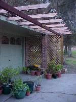 I finally got the plywood off the house just today. Most of it is still lying in the yard where it landed. Tomorrow, I'll remove the 2x4 stiffeners and store the plywood in the garage. I'll cut up the 2x4s to make rafters for the pergola I'm building along the front of the house. If we have another hurricane, I'll repeat the process. Eventually, I'll have enough 2x4s to finish the pergola.
A friend wrote:
I'm glad you have no significant damage, but you don't mention anything about water. Was there any flooding at or near your place? Did you see any signs of it in your area as you returned home? Did the bay side of Galveston get any flooding? It seemed from the reports it would have, but I've heard nothing.
And did you carefully mark and store the plywood for the windows, or pitch it?
There was no flooding here, and there was no evidence of flooding anywhere along our route home.
Flooding can occur here for any of three reasons:
- Local rainfall. Apparently, local rainfall was minimal: the flower beds were dry, and one of the first things Ann did after we arrived home was water them. The ditches are dry all the way to the bottom, which is typical for summer. A friend who works at the Brazoria National Wildlife Refuge reported that "we received virtually no rain (maybe half an inch)."
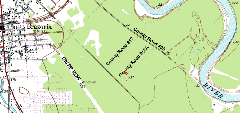
- Upstream rainfall. We live within a mile of the Brazos River, so upstream rainfall affects the river level here. As of Monday, it appeared to be at its normal level; officially, it was 38 feet below flood stage at Richmond, the nearest gauging station. According to the Houston Chronicle, it actually receded 0.2 feet during the 24-hour period Sunday-Monday. Historically, the Brazos has flooded several times (the locals still talk about the Great Flood of '49), but it has never flooded over its banks since we've been here. This photo shows an abandoned roadway piling in two situations: normal water level (as it appears now) and at the highest level I've every seen. I was standing on the bank when I took these pictures; even at high water, I was 10 or 15 feet above the water line.
- Storm surge. The storm surge never came near us. According to the evacuation map, our property lies in Zone B, just south of the line between Zones B and C. Which means we'd be within the storm surge zone for a Category 3, 4, or 5 storm if the storm made landfall at Freeport. Fortunately (for us) it arrived way to the east of us.
Galveston had extensive flooding. Most of the island is less than 10 feet AMSL, and it's adjacent to the Gulf, so storm surges roll right in. Since the bay is also at sea level, I assume the island was flooded from all sides.
I finally got the plywood off the house just today. Most of it is still lying in the yard where it landed. Tomorrow, I'll remove the 2x4 stiffeners and store the plywood in the garage. I'll cut up the 2x4s to make rafters for the pergola I'm building along the front of the house. If we have another hurricane, I'll repeat the process. Eventually, I'll have enough 2x4s to finish the pergola.
posted by Neal McLain at 9/27/2005 05:00:00 PM
![]()

<< Home